ook beschikbaar in het Nederlands

For the creation of all RAGiF’s (Routaki Audio Guide info Files) a lot of research has been done on all aspects of Crete. This resulted in at least 300,000 words of information divided over the different subjects. On this page you will find links to the pages where you can read the whole (or the basic) story for the information that is played to you in audio form when you drive or walk one of the Routaki routes.
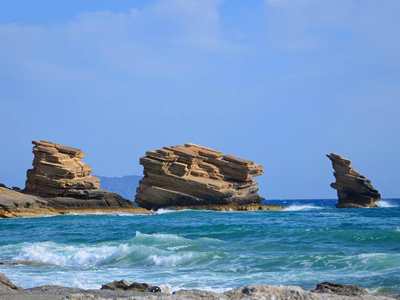
Triopetra - one of the geographical aspects of Crete - geographical facts crete
Crete is a long strip of land which, from East to West, borders about 260 km of Europe. With its surface of 8.261 km2, Crete is the largest greek island and the 5th largest in the Mediterranean Sea.

Read more about Crete in general.

Crete has a coastline of a bit more than 1.000 km. It’s the Southern closure of the Aegean Sea, where the waters above Crete are called the Cretan Sea (Greek: Κρητικό Πέλαγος).

Read more about the seas around Crete.

The most eastern mountain chain on the island of Crete is the one of the Dikti highlands. The mountain range is especially known for the Lassithi plateau which is situated on it.

Read more about the Dikti mountains on the eastern part of Crete.

The lake of Kournas can be enjoyed with a trip on a pedalo. They are for rent and will give you a great opportunity to explore this beautiful place. At late summer or autumn the water level drops so much that white sandy beaches are exposed.

Read more about the Kournas lake.

Crete does not have rivers that you can sail along. For a significant part, Crete consists of lime stone that lets water through easily which causes the so called ‘karst’ symptoms.

Read more about the landscape and stone type.

Crete consists a big part of lime stone. This type of stone is very porous and easily lets water through, what causes so called karst symptoms. The water dissolves the lime stone and so caves, underground rivers and lakes are created.

Read more about the landscape and the earthquakes

Near the village of Melidoni you have the possibility to visit an amazing cave known as the Melidoni cave. It’s also called the Gerontospilios Cave

Read more about the Melidoni cave – in Route 42 – ‘Margarites’

On the South coast, in contrast with the North coast, the landscape is a lot tougher. In a way it seems like the mountains crash in the sea, making it easier for gorges to form.

Read more about the some gorges on Crete

The Messara area is a fertile flantland which is protected by mountain ranges on three sides; on the North side by the Ida highlands, on the East side by the Dikti highlands and on the South side by the Asterousia highlands.

Read more about the Messara plateau

The Milatos Cave has this terrifying story about 3600 people, mainly women and children who were killed by the Ottoman Turks.

Read more, about the Milatos cave which is an item in Route 58 – ‘Spinalonga’

Crete has no rivers and only freshwater lake. Off course it’s surrounded by many waters.

Read more about the names of these waters.

Available route where in you will drive through the Vineyards south of Heraklion:
Route 53 nicknamed; Knossos

In the VoiceMap app you’ll find this route under the name:

The treasures of Knossos unveiled: from Hersonissos through Archanes’ vineyards

busy in september - the grape harvest in Crete

Enjoy & Share & Pass on your experiences

Of course, we appreciate it if you share your experiences with your family and friends on social media.