What does RAGiF stand for?


nederlandse tekst voor deze pagina

RAGiF is the abbreviation for Routaki’s Audio Guide info Files.

These audio files provide you with interesting information about items you will encounter along the way or general information about the region or country where you’re currently driving through. The RAGiF’s are integrated in the car route or city walk that you use, when using the VoiceMap app. This APP makes sure that the right RAGiF is played at the right GPS coordinate, during your chosen road trip.
What is /what does the VoiceMap app?

VoiceMap’s tours are generally created by knowledgeable local storytellers, including journalists, filmmakers, novelists, podcasters, and tour guides. For Crete, the tours are crafted by Mr. Routaki, a passionate island enthusiast who has spent many seasons exploring and uncovering ‘off the beaten track’ locations.

• VoiceMap works offline. Once you download a tour, both the audio and map will be available offline.

• With GPS autoplay, you can fully immerse yourself in your surroundings. Place your smartphone in a holder or use headphones while walking, tap Start, and let the VoiceMap app guide you.

• If you happen to take a wrong turn, VoiceMap will alert you with an audio notification, and you can follow the map on your screen to get back on track.

It’s a good idea to explore the app’s features before you set off. You can adjust the screen size, tilt it, and more. You can pause the tour whenever you like or even step away for a while. The ‘RESUME‘ button will bring you right back into the tour when you’re ready.

All of this, while on the spot in Crete. But if you want to get a head start, you can enjoy the pre-fun from the comfort of your couch at home. Listen to the tour in audiobook form, or read along at the same pace as Mr. Routaki narrates the experience for you.
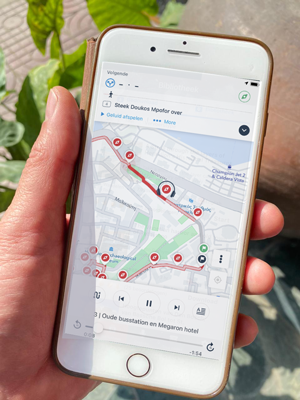
the VoiceMap app in full use

What does Routaki’s ABC entail?

This ABC is a short list of points that we want to give you before the route. You can read them below:

Clothing advice: We would like to point out that on most routes there are places to visit or walk, for which good shoes are essential. It’s also recommended to apply sunscreen because, in a moving car, you may not notice how much the sun is burning (especially in a convertible). If you want to visit chapels or churches, appropriate clothing is expected.

Driving in bends: If you are not used to driving in the mountains, here’s a small tip: always try to accelerate gently through the bends. So, give a little gas as you go through the turn. When descending, brake with the engine (using the same gear as when ascending).

GPS-interactive: The VoiceMap app, which Routaki uses for the routes, utilizes your GPS position. Audio files are played at the right time, taking into account the length of the files, so you don’t miss the next POI (Point of Interest).

Offline use: This means you won’t need the internet during the trip. You load the route into VoiceMap while you’re still at home or in your accommodation. Then, once you’re on the road, everything runs offline. It’s a good idea to bring a phone charger, as the experience shows that your battery may not last the entire route.

Private property: Please respect other people’s belongings at all times. Tourists are very welcome here on Crete, but a farmer who suddenly finds, for example, his hammer missing, won’t be happy. A small example to remind you to be mindful. Also, make sure the car is parked neatly without causing any inconvenience.

RAGiF’s: Routaki’s Audio Guide Info Files, or the audio clips that make your day with Routaki so special. We’ve tried to play these at moments when you don’t need to make too many turns or take exits. Enjoy the information.

Responsibility: Routaki is in no way responsible for any inconveniences. The route description and the RAGiF’s are copyrighted: © Routaki 2024.

VoiceMap: This is the app that Routaki has been using since 2000 to display the routes and city walks. This South African start-up continues to develop and improve its app.

Waste: We, at Routaki, aim to provide everyone with a fun and enjoyable day trip. However, we kindly ask for your help in keeping this beautiful island clean. Although we are aware that the locals sometimes overlook this, we still appeal to you. Please take all packaging, food scraps, etc., with you or dispose of them directly in a container. Thank you in advance.

Wrong turn: If you take a wrong turn, don’t worry. The VoiceMap app will notify you that you’re leaving the route. Check the screen to see how to get back to the red line. If you’re back on the route and the app doesn’t detect your position, it can help to press the ‘Resume’ or ‘Hervatten’ button.

Enjoy the itineraries and the RAGiF’s from Routaki.

Mr. Routaki

Nederlands talige teksten

What is augmented reality?

Augmented reality (AR) is the integration of digital information with the user’s environment in real time. In other words a live (in)-direct view of a physical, real-world surrounding whose elements are augmented (increased or supplemented) by computer-generation. It is related to a more general concept called mediated reality, in which a view of reality is modified by a computer.

It’s going to be a future form of a Routaki route.

Unlike virtual reality, which creates a totally artificial environment, augmented reality uses the existing environment and overlays new information on top of it. As a result, the technology functions by enhancing one’s current perception of reality. With Augmented reality it’s possible to add graphics, sounds, videos and/or smell to the natural world as it exists. With the help of advanced augmented reality technology, the information about the surrounding real world of the user becomes interactive and even digitally manipulable.
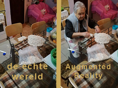
Can you realise the possibilities with Augmented Reality as a guide with Routaki

Some examples of Augmented reality already used: